

Kippure [Cipiur]
Good walks are even better shared.
O1115 : Dublin: Kippure Mountain Summit, Triangulation Pillar
Michael Murtagh Photo source
Overview
Kippure [Cipiur]
Kippure, often affectionately referred to as 'The Hump', stands proudly at 757 meters (2,484 feet) within the breathtaking Wicklow Mountains. This Marilyn is not just a treat for the eyes but a great exercise opportunity for your legs and lungs!
Geology
The mountain is predominantly quartzite and sandstone, a legacy from the Carboniferous period. The unique geology not only contributes to its impressive stature but also to its fascinating landscapes. Some may say Kippure rocks — quite literally!
Routes
Kippure Loop
This 7.5 km circular route from the Kippure Estate is a favourite, taking approximately 3.5 hours to complete. It weaves its way through lush green valleys and along picturesque ridges, guaranteeing a scenic delight along the way.
Ascent from Glencree
For a direct approach, the ascent from the Glencree valley spans about 6 km and takes roughly 2.5 hours. The steep sections add a bit of a workout, while the views become more mesmerizing with every step you take.
Summit Features
At the summit of Kippure, you will find a trig point and a large cairn. You'll also be surrounded by awe-inspiring landscapes that seem to stretch on forever. Don’t forget to take a selfie with the trig point — it’s a rite of passage!
Terrain Type
Expect a medley of terrain: grassy slopes, rocky paths, and the occasional bog. Pack your wellies just in case!
Views
The views from the top are nothing short of spectacular. On a clear day, you can see Lugnaquilla and the Spink looming in the distance. And if you're lucky, the shimmering Irish Sea may make an appearance on the horizon!
Hazards
While hiking is a joy, be aware that weather can change faster than a rabbit in a hat, so bring layers. And for those less sure-footed, keep an eye out for those boggy patches!
Nearby Summits
If you’re feeling adventurous, check out nearby summits like Lugnaquilla (925 meters) and Buck Hill (691 meters) to extend your hike.
Access
Parking is available at the Kippure Estate, complete with a café for any pre or post-hike refuelling. Public transport from Dublin can connect you to the nearest town of Enniskerry, which provides a delightful pit stop before or after your exploration.
Facilities
The Kippure Estate boasts a café and toilet facilities. Always handy to know before you head off!
History
Kippure's name comes from the Irish 'Cipéir', which fittingly means 'The Hump'. Historically, it’s served as a notable guide post for explorers of the rugged Wicklow landscape, attracting walkers for generations.
In summary, Kippure is not just a climb; it’s an experience worth savouring. Ready your boots and pack your enthusiasm — the mountains are calling!
Explore routes near Kippure [Cipiur]
Walks starting near this hill. Open a route to check its map, distance and full itinerary.
Route planning notes
These notes describe possible approaches. Check a route's map and access information when planning your walk.
Kippure Loop
A popular circular route starting from the Kippure Estate, offering a scenic trek through lush valleys and along grassy ridges.
Ascent from Glencree
A straightforward ascent from the Glencree valley, with some steep sections and rewarding views as you climb.
Make a day of it, together
Find someone to share the walk with, or organise a day out along a route you like.
Photo Gallery
View all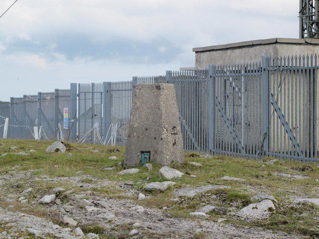 Photo could not load
O1115 : Dublin: Kippure Mountain Summit, Triangulation Pillar
Michael Murtagh
Hill facts and local notes
Classifications
Elevation
757m
2,484 ft
Prominence
262m
Coordinates
53.1782, -6.3321
O115154
OS Map
56
At the Summit
The summit features a trig point and a large cairn, surrounded by breathtaking landscapes that stretch across the Wicklow Mountains.
Terrain & Geology
Kippure is predominantly composed of quartzite and sandstone, giving it a rugged and striking appearance. The geological formations date back to the Carboniferous period, making them quite the ancient landscape.
Views & Scenery
From the summit, hikers can enjoy views of the Spink, Lugnaquilla, and the sprawling valleys below. On a clear day, the Irish Sea can even be spotted!
History & Heritage
Name Origin
Kippure's name is derived from the Irish 'Cipéir', meaning 'The Hump', likely due to its distinctive shape when viewed from the surrounding valleys.
Historical Significance
Historically, Kippure has been a favourite among walkers and climbers, serving as a landmark for those navigating the rugged landscape of Wicklow.
Getting There & Facilities
Parking
There is parking available at the Kippure Estate, which has ample space for vehicles and access to a café.
Public Transport
Dublin is the closest city, with public transport options including buses that serve the area. Check local services for the best routes.
Nearby Facilities
The Kippure Estate has a café and toilet facilities, ideal for a pre-hike coffee or post-hike treat.
Safety Information
Known Hazards
- Be mindful of sudden weather changes, as conditions can shift quickly in the mountains. Certain routes can be boggy, making proper footwear essential.
General Safety Tips
- Check weather conditions before setting out
- Carry appropriate clothing and equipment
- Let someone know your planned route
- Take a map, compass, and GPS device
- Carry emergency supplies: food, water, first aid kit, torch
Hills
Some common questions about the hills answered
Are there group walks up Kippure [Cipiur]?
Many walkers use Walkmates to join or organise walks with others. You can check for group walks around Kippure [Cipiur] through the maps
Are there other walkers around Kippure [Cipiur]?
Activity varies by location and time, but Walkmates lets you see whether others have shared walks or shown interest in this area. Find other people through the walking friends search walking friends for Kippure [Cipiur] search or of course create your own walk for Kippure [Cipiur]
Can I organise a walk to Kippure [Cipiur]?
Yes. If there aren’t any walks listed already, you can create a walk and make it available for others to join.
If you're signed up to Walkmates, you can create a walk to Kippure [Cipiur].
How do I find a walk up this hill?
There are often multiple ways to walk this hill, depending on experience and route preference. Walkmates helps you explore walks and routes that others have shared.
Can I suggest a new route up Kippure [Cipiur]?
Yes. You can suggest or create routes to share with others. Walkmates focuses on the social side of walking, so routes are used to help people organise walks and explore areas together, rather than as detailed navigation tools or route libraries.
Other uses really appreciate knowledgeable walkers sharing their routes. Share your favourite route to Kippure [Cipiur] here
The is an error or something incorrect about this hill. How do I let you know?
We always strive to keep the information on Walkmates as accurate as possible. If you find an error, please let us know through the contact form and we'll aim to correct it as quickly as possible
Community Discussion
Comments
Location
![Kippure [Cipiur] location map](https://cdn.walkmates.com/hill-maps/hill-sources/20060/53.17820_-6.33209.png)
Grid reference: O115154
View on OpenStreetMapOpens a map in a new tab, centred on the hill.
Nearby Hills
Mullaghcleevaun
847m
Lugnaquilla [Log na Coille]
925m
Slieve Foye
587m
Slieve Gullion
576m
Slieve Binnian
746m
No comments yet. Be the first.